Showing posts with label Emily Ressler. Show all posts

7/28/11

My Leki Makalu Thermolite Trekking Poles

I (JD) recently had my FOURTH knee surgery on my right knee about 2 1/2 months ago.  I had never been much of trekking pole user during all my years of hiking (I have had a pair sitting in my gear room for about 2 years now), but decided after this last surgery that maybe it is time to try them out.

The White River in Missouri.

We have been in Missouri the last couple of weeks trying to finish up some hikes for our Best Easy Day Hikes Ozarks Falcon Guide and I decided to use this time as a trial for my Leki Makalu Thermolite Trekking Poles.  One word sums it all up for me, WOW!  I cannot believe the difference that a couple of lightweight sticks made for me.  Not only did I find that the poles transferred some of my load/weight over from my knees to the poles (as advertised), but I also found that my posture improved while hiking (helping my lower back to feel better after a long day on the trail).  I also took a lot less stumbles on the trail with the added balance (it was a stumble coming down Iztaccihuatl in Mexico that did me in last time).


Gettin my hike on!

It is pretty safe to say that I am sold on my Leki's.  The set of poles I used have the super locking system on them which I prefer over the newer speed locking system.  I like the idea of the speed locks, but have found that the current design (the small speed locking handles) is easier to get snagged on pant legs, bushes, etc.

I am looking forward to working on our Albuquerque guide so I can give my poles another workout!

7/7/11

Elephant Rocks - Braille Trail

Elephant Rocks State Park is well known to locals in Missouri.  The 1.5 billion year old granite rocks sit mysteriously on top of one another in the park.  Some of the rocks tip the scales at over 680 tons!

The Braille Trail is Missouri's first trail that has been designed for people with visual and physical disabilities.  The one mile trail circles through and around the large boulders of Elephant Rocks and guides hikers with braille interpretive signs and numerous natural features for people to get a hands on experience.

Elephant Rocks State Park is located just north of Ironton, MO on MO-21.

 A family attempts to move "Dumbo".  Over 680 tons of granite.


 Don't forget about the little things in the park.


More of the little guys.

6/13/11

Book Signing Dates

We have a couple of book signings in the works!  One signing and presentation is all set for July 16th at the Alpine Shop in Kirkwood, MO.  We will be signing copies of our newest Falcon Guide, Best Easy Day Hikes St. Louis.  Check out this link with more info: https://alpineshop.webconnex.com/booksign


The second signing is just now in the works and looks like it will take place at the Outdoor Retailer Summer Market Show this summer.  We will be signing FREE copies of our Hiking Grand Staircase-Escalante & the Glen Canyon Region Falcon Guide.  Saturday August 6th is looking like the day!  VERY EXCITING! 


6/5/11

A Short Hiatus

After a quick knee surgery hiatus (JD'a 4th on the same knee, YIKES!), wrapping up a school year (Emily's 1st, DOUBLE YIKES!), and multiple trips to Provo Utah (nobody should be required to visit Provo 5 times in a year!) we are ready to hit the outdoors again!

We recently kicked off the summer with a three day float down the San Juan River in southern Utah.  We put in at Bluff, UT and rafted about 27 miles down to Mexican Hat, UT this last week.  Us and several staff that JD works with all hit the river for a laid back post Memorial Day celebration.  Check out a few pics:

Getting unloaded.

 JD and Emily at the River House Ruins.

 Desert life.

 Emily and Ashley at the Ruins.

 Willy Wonka's Chocolate River (AKA the San Juan River). We are still finding sand in our crevices!

Emily working the oars with the Mexican Hat in the background.

4/22/11

Mexico 2011

Here are a few photos from JD's mountaineering trip to Mexico last month.  Mexico was amazing and I cannot wait to go back on a personal trip with Emily and back with SJC in two years.

Enjoy!

4/13/11

North Carolina Highpoint

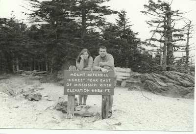
On May 29th, 2005 we made our way to the highest point in North Carolina.  Mount Mitchell towers above the Appalachian mountains in western North Carolina at 6,684 feet.  Located along the Blue Ridge Parkway and within Mount Mitchell State Park, this highpoint offers plenty of scenery.

The Drive: Take the Blue Ridge Parkway northeast out of Asheville, NC for about 30 miles to State Route 128 at mile marker 355.  Turn left at the well signed Mount Mitchell State Park entrance.  Continue for about 4.2 miles on SR 128 until you reach the parking area.

The Hike: Take the well signed path past the museum/visitor center up towards the stone lookout tower located at the summit (only a 5 to 10 minute hike).

Here we are at the summit.

4/2/11

Its on the Shelves!!!

Okay people.  It hit shelves yesterday!  Look for it in stores like Barnes & Noble, REI, Alpine Shop, etc.  Our first St. Louis book is also available online through stores like Barnes & Noble, BordersTarget and many others.

Our more comprehensive book, Best Hikes Near St. Louis, is going through the editing process right now and should hit shelves before the end of the year.


Keep checking back for a date when we will be in St. Louis SIGNING and giving away FREE ones!!!


3/30/11

A Busy Spring is Gonna Turn Into a Busy Summer

So, we are right in the middle of a busy spring.  Emily just got back from Missouri where she was working on wedding plans and a hiking guide, and JD just got back from Mexico where he conquered his first 17 thousand foot plus peak.  JD has an AMGA training and then a knee surgery in April along with a Challenge Course Practitioner Training in May.  Emily is sooo close to wrapping up her first year of teaching and cannot wait for the summer!  We are also expecting one new book contract soon from Falcon Guides for a Best Hikes Near Albuquerque book.

By the end of May we'll be heading to Springfield, MO to finish up a hiking guide there so we can turn right around and co-instruct an Expedition Backpacking class for San Juan College near Taos, NM.  Right after that class we'll head back to Missouri for our wedding (it only took 7.5 years!) and then we'll honeymoon in the Ozarks where we'll be wrapping up hiking guide NUMBER SIX.  While all of that is going on, we'll be spending weekends in and around Albuquerque working on guide number 7 and waiting to see if we get offered an 8th book which will be a rewrite of the Falcon Guides Leave No Trace pocket book.


Oh, did I mention we will probably be in Cody, WY in August?


3/18/11

Mexico City and Jackson, MO!!! Here we come.

Spring Break is here!  JD is headed to Mexico to climb two volcanic peaks and Emily is headed to Missouri to work on a hiking guide.  JD will be sending sat phone updates to Emily and she will posting updates here and on Facebook.

Stay tuned!

3/6/11

Possibly, My (JD's) New Favorite National Park

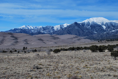
I stopped in for a quick visit to Great Sand Dunes National Park near Alamosa, CO the other day.  I've been near it before, but have never stopped in.  I'm so glad I finally did!  The Dunes were amazing!  They reach 750 feet high in some places and cover almost 40 square miles (and can be seen from space).  To top it off, the Dunes have 14,000 ft peaks to the north and south (we have climbed Blanca and Ellingwood in the past).

A small portion of the Dunes. 

Blanca, Ellingwood, and Little Bear (all 14ers) sit near the Dunes.

2/24/11

Chaco Canyon NHP

Last weekend we took a trip down south to Chaco Culture National Historic Park.  What an amazing place!  The canyon was littered with Chaco Culture ruins that dated back as late as 850 A.D.  The best part was that you could actually walk through the ruins into several of the rooms within the buildings.  There were also numerous backcountry trails that we are gonna go back for as well as biking trails.  Check out some pics:


Emily, investigating the ruins. 

A Kiva in the Pueblo Bonito.

2/4/11

Brasstown Bald

On Memorial Day weekend in 2005 we took off for our second highpointing trip.  On May 29th we arrived in northwest Georgia to knock off Brasstown Bald (4,784 feet).  It was only a .5 mile walk up to the highpoint from the parking area, but well worth the views.  If memory serves, I believe we had to pay a parking fee. Three bucks maybe?

The Drive:  From Blairsville, GA, drive 8 miles south on US 19.  Turn left onto State Highway 180 and drive another 9 miles.  Turn left onto State Highway 180 Spur and continue 3 miles to the parking area. (a bike race that Lance Armstrong was in was held there just a few days before us. people had written "Go Lance Go" all over the road)

The Hike:  You can locate the paved trail next to the gift shop and hike the short .5 mile to the tower on top of the mountain.  Return to your car the same way.

 Emily stops along the trail for a picture.


JD, as high as he can get on the tower. 

1/30/11

Emily's 3rd Cover Photo!

Emily's 3rd Falcon Guide cover photo will grace the cover of Best Easy Day Hikes St. Louis.  Due out April 1st.  Take a look!


JD and Arnie's best sides.

1/16/11

Ice Climbing in Cascade Canyon

Today we took ride up to Durango Mountain Resort for the Winterfest that was taking place.  Backcountry Experience and Kling Mountain Guides were offering FREE guided ice-climbing trips during the Winterfest and we were all like, "let's do it."

After checking in and taking a short 2 minute ride to the Cascade Canyon trailhead we were climbing!  Southwest Colorado is known for it's ice-climbing and has become a world destination for it.


Emily, sizing up the route.


 A few moments of instruction.


 Emily cruises up the frozen waterfall.


A look into the canyon.

1/8/11

Our 4th Highpoint

Our 4th highpoint was the closest to us back in 2004.  In August of 04 we headed over to Taum Sauk Mountain State Park in Missouri to conquer 1,772 foot Taum Sauk Mountain.  Conquer might be a bit of an exaggeration since you drive to the parking lot and walk about .2 mile to summit, but the highpoint is just the first of the adventures you can have here.

The Drive:  From Arcadia, MO take SR 21 southwest for about 4.5 miles.  You will pass the "Tip Top Roadside Park" and turn right (northwest) not long after where the sign points to Taum Sauk Mountain State Park.  Follow the paved road for 3 miles and stay right at the fork where the pavement ends.  Continue about .4 mile on the gravel road to the parking area.

The Hike:  From the parking area it is just a short walk on a paved trail.  Walk west for about .2 mile where the sign points to highpoint.

Extend your trip by visiting Mina Sauk Falls (the highest falls in Missouri) and the Devil's Tollgate.  These detailed hikes can be found in our upcoming Best Hikes Near St. Louis Falcon Guide!

JD, Arnie, and Aspen at the MO Highpoint.

1/1/11

The "Low" Highpoints Continue

Florida was number three on our list of highpoint adventures.  The lowest of the state highpoints (345 feet above sea level), Britton Hill can be found out on the Florida Panhandle.  Not a super huge expedition since you simply drive to it and get out for a picture, but it is still on the list.

The Drive:  Starting in Florala, AL, drive east for 1 mile on SR 54.  Almost immediately after passing the 1 Mile marker sign, turn right onto an unmarked paved road and drive .2 mile before entering Florida.  Here the road becomes SR 285.  Drive another .8 mile to the small park on the right.

The Hike: Again, it's a drive to.  No hiking required.

 This sign can be seen from the road.


The monument in the park.

12/21/10

Mesa Verde National Park

Today we hit up Mesa Verde National Park (only 1 hour from our house) in southwest Colorado.  Pete, Erin, Chris, Arnie, Aspen, and us all went up for the day to explore a little.  The pictures below are from the Mesa Verde Spruce Tree House.

Did you know that there are over 600 cliff dwellings in Mesa Verde NP?

 A view from the Mesa.


 Approaching the Spruce Tree House Ruins.


The Ruins.  The ladders lead down to the kivas.


12/19/10

Cheaha Mountain

Our second highpoint was a part of 3-highpoint trip.  We came across the adventure of highpointing when we were making plans to meet up with family in Florida in the summer of '04.  After hitting up Mississippi's highpoint first, we made our way to Alabama.  A little more exciting than MS as Alabama's highpoint is actually a state park (Cheaha State Park) and reaches an elevation of 2,407 feet.

The Drive: From Birmingham, take I-20 east to Exit 191 and turn south onto US 431.  Continue 3.5 miles before turning right onto a road with a sign pointing to SR 281.  Drive .6 mile and turn left onto SR 281.  Drive 12 miles on SR 281 to the park entrance on the right.  Take the one way road to the right and drive up to the parking area where you will see the sign pictured below.

The Hike:  The hike is more like a leisurely walk as you only need to walk a short distance from the parking area to the tower you see pictured below.

 Emily at the State Park sign and parking area.


Here we are at the tower/highpoint.

12/16/10

Our Highpoint Adventures

We are gonna start a series of posts about Highpointing Adventures.  If you don't know, Highpointing is trying to reach the highest point in a state.  We started our journey on June 20, 2004 and have reached 41 Highpoints in the U.S. so far and have a few more coming up soon.

Let's begin with our first:  Mississippi (6/20/04) - We'll have to admit, not an exciting first highpoint but we had to start somewhere.

The Drive There:  In the northeast corner of the state you will find Woodall Mountain by taking US 72 east into Iuka, MS.  In Iuka turn right onto SR 25 (south) and then a quick right onto Fairground Road (CO 187).  Follow Fairground Road for 1.1 miles to CO 176 and turn right onto CO 176.  You will see the sign pictured below at this turn.  Continue .7 mile to another sign on the right and turn right onto the gravel road.  Follow the road for about 1 mile before reaching the highpoint.

The Hike: No hiking required.  Take a look around. Pretty boring.  Our next posts will be a bit more exciting.

 First sign pointing towards highpoint.

The highpoint survey marker.

12/11/10

Angel Peak

Today we visited the Angel Peak Scenic Area just outside of Bloomfield, NM.  A part of the San Juan Basin Badlands, Angel Peak is almost 7,000 feet above sea level.  A lot people think it isn't as "cool" as the Bisti Wilderness Area because it doesn't have as many hoodoos, we would disagree.  The landscape was very similar to South Dakota Badlands which we loved.

From Farmington, we drove 27 miles to the turn-off.  We turned east onto the signed "Angel Peak Scenic Area" road and drove to the campground.  From the campground we took off hiking and made our way all the way to the bottom floor of the Badlands.  Check out some pics:

 Angel Peak


 Hiking down  the ridge.


Making our way to the valley floor.

ShareThis